Hi!!!
This trip was me and my Laura’s first together-solo hike! We didn’t want to hike on the holiday but no one wanted to hike on a Monday. This trip got 3 more mountains off my list PLUS bonus Avalon! Mount Avalon has the best views but it is too small to be a 4,000 footer. It is on the 52 with a View list which we will work on after I get my NH 4,000 footer club patch. I have a head start on my 52 though!
We started at the parking lot with a train station. Make sure to get on the right side of the tracks to start. There is some water to cross and drink for the first part of the trail. We went up the Avalon Trail first on this loop and when you leave the junction with A-Z Trail, there is no more water to drink. There was some wetness on the steep, rock trail to Mt Avalon so I liked that we went up first even though the best peak is first instead of last.
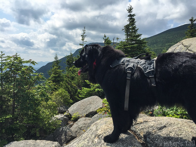
Avalon is 100 yards off the main trail and it requires climbing but it is so worth it. You can see the other side of the Crawford Notch which is all mountains I still need to climb. Webster, Jackson, Pierce, Eisenhower, Monroe, Washington, Jefferson, Adams, Monroe… Oh yeah the presidentials! Actually, I don’t think you can see all of them from here. Washington is big and gets in the way. If you turn around you can see the three big-mountains for the rest of the trip!
When you’re done with Avalon, keep going up more until the Willey Range Trail which means just around the corner is Mount Field! #16 for me! It is a pile of rocks in the woods but there is a place for views where you can see the Mount Washington in hotel form and have LUNCH! This lunch was new stuff: TurboPUP. It is my new favoritist thing in the world. Besides my family and hugs and tag. Well, maybe more than hugs. TurboPUP then hugs when I’m done.
From Field you have to go down to get back up to Willey. That’s the rule. It felt like there were three times where you think you are at the bottom of the col (I learned this little word means low point between mountains!) but it wasn’t true. Then after going steadily up you go down one more time but it’s okay because just up and around the corner is the summit! #17! Another pile of rocks in the woods! But what you need to do is go 50 human-paces past to a little side trail with an awesome view of Webster cliff.
For the record, people keep saying that the other way up Willey (and why do some people call it Wiley?) has ladders so I couldn’t go that way. But they lied! It is stairs! I’m a stair master! I guess lots of stairs are boring and if you go up that way and down Avalon you have to walk the road. I like the woods so going back to Field was ok. More TurboPUP!
It’s a nice walk down Field to where you get to Mt Tom spur. This trail is not hard or steep except for one piece which was like giant stairs. Near the top it was confusing but I think we went left to find the - guess - pile of rocks in the woods! #18! It is underwhelming, especially for short people and dogs because the “view” past the pile of rocks in the woods is over trees. That would be a good reason to do this trip the other direction and save Avalon for last.
At least the A-Z trail is only steep for a little bit and not as bad as the Avalon Trail. I got some water in streams on the way down these trails. At the very end we passed a group of girls from a camp and they adored me back at the parking lot. Yes yes, I am a ladies-dog.
Bye!
~Frisco
Tom, Field, Willey
Elevation: 4,051 ft, 4,340 ft, 4,285 ft
Trails: Avalon Trail, Willey Range Trail, Mt Tom Spur, A-Z Trail
Distance: 10.3 miles
 |
| The correct side of the tracks is the woods side. |
This trip was me and my Laura’s first together-solo hike! We didn’t want to hike on the holiday but no one wanted to hike on a Monday. This trip got 3 more mountains off my list PLUS bonus Avalon! Mount Avalon has the best views but it is too small to be a 4,000 footer. It is on the 52 with a View list which we will work on after I get my NH 4,000 footer club patch. I have a head start on my 52 though!
We started at the parking lot with a train station. Make sure to get on the right side of the tracks to start. There is some water to cross and drink for the first part of the trail. We went up the Avalon Trail first on this loop and when you leave the junction with A-Z Trail, there is no more water to drink. There was some wetness on the steep, rock trail to Mt Avalon so I liked that we went up first even though the best peak is first instead of last.
 |
| Avalon Summit |
 |
| Field Summit pile-of-rocks |
 |
| om nom nom |
When you’re done with Avalon, keep going up more until the Willey Range Trail which means just around the corner is Mount Field! #16 for me! It is a pile of rocks in the woods but there is a place for views where you can see the Mount Washington in hotel form and have LUNCH! This lunch was new stuff: TurboPUP. It is my new favoritist thing in the world. Besides my family and hugs and tag. Well, maybe more than hugs. TurboPUP then hugs when I’m done.
From Field you have to go down to get back up to Willey. That’s the rule. It felt like there were three times where you think you are at the bottom of the col (I learned this little word means low point between mountains!) but it wasn’t true. Then after going steadily up you go down one more time but it’s okay because just up and around the corner is the summit! #17! Another pile of rocks in the woods! But what you need to do is go 50 human-paces past to a little side trail with an awesome view of Webster cliff.
 |
| Webster Cliff from Mt Willey outlook |
For the record, people keep saying that the other way up Willey (and why do some people call it Wiley?) has ladders so I couldn’t go that way. But they lied! It is stairs! I’m a stair master! I guess lots of stairs are boring and if you go up that way and down Avalon you have to walk the road. I like the woods so going back to Field was ok. More TurboPUP!
 |
| Heading back down |
At least the A-Z trail is only steep for a little bit and not as bad as the Avalon Trail. I got some water in streams on the way down these trails. At the very end we passed a group of girls from a camp and they adored me back at the parking lot. Yes yes, I am a ladies-dog.
Bye!
~Frisco
Tom, Field, Willey
Elevation: 4,051 ft, 4,340 ft, 4,285 ft
Trails: Avalon Trail, Willey Range Trail, Mt Tom Spur, A-Z Trail
Distance: 10.3 miles
No comments:
Post a Comment