Hi!!!
Team Locomo took on the epic Tripyramid loop for two more peaks off everyone’s list! I know these big-mountains are called the Tripyramids but only two get to count on the 4,000 footer list. It sounds like false advertising. North and Middle count but poor South Tripyramid doesn’t get any love. (Laura Note: It is on the Trailwrights 72)
Our Trip started on the Livermore Trail. But you know what? It’s not really a trail. It is a ROAD! A nice, smooth, dirt road that my car could drive on. But did we drive? nope. We walked 3.6 miles on a ROAD. I mean, it’s not hard but it is kind of boring. The loop starts at 2.6 miles but you have to go clockwise-north first so still another mile before the real trail!
At a sharp turn in the ROAD the Mt Tripyramid Trail starts! If you don’t like climbing don’t go this way. Or if it’s raining. Take the ROAD to the Scaur Ridge Trail. We wanted to do the traditional Loop so we went the hard way.
First you go down to cross Avalanche Brook. Drink up and fill up! You hike like a normal hike for a little bit with the anticipation building and then STEEP SLIDE! The bottom is smooth rocks with moss that stays wet so it is slippery. I’m pretty good at climbing but a few times I needed some help. You have to pick which way to go carefully. I saw another dog try to go around us and then he got stuck because he couldn’t go up anymore. He had to go down and back up.
The top half of the slide was easier because it wasn’t slippery or mossy. You can see a lot from up there. It was supposed to rain later that evening but there was already a cloud ceiling. Some mountains were touching the ceiling! We made friends with some girls who climbed up at the same time and traded photos. We kept passing each other on the trail. At North Tripyramid we took victory photos and ate first lunch. It was hard work rock climbing a mountain. We met a local who said it wouldn’t rain.
After snacking (TurboPUP I love you), we continued on which meant going down and then back up to Middle Tripyramid. There was a friendly summit-mushroom welcoming us. We ate more food and met a Forester taking care of the forest. She said it wouldn’t rain.
We continued to South Tripyramid as the clouds were covering the mountains. we looked back at the pointy peaks and could just see them through fog. The South summit wasn’t much, probably because it doesn’t get the love. But guess what? It started raining! I need a raincoat. My Laura and Moriah have red raincoats. I should have one too. We took our time going down the South Slide because it was wet and slippery. It rained steadily for a while down the top half of the slide. It was steep but not as bad as the North side. It is more rocky-sandy instead of big slabs of rock. We kept taking our time and eventually got back to the trees and the not-steep part as the rain slowed down.
When you’re done all the hard stuff, it is actually a long hike back. There are streams to drink and it is not steep but it takes a while. When you finally get back to the loop it is 2.6 miles on the Livermore ROAD back to the car. We ran a little bit on the ROAD because it is flat to speed it up. All together the hike is 11.1 miles but it actually doesn’t feel like that much because half of it is on a ROAD. But remember, half of it is STEEP STEEP STEEP. (Three steeps for three peaks!)
Bye!
~Frisco
North Tripyramid & Middle Tripyramid (& South Tripyramid)
Elevation: 4,180 & 4,140 ft (& 4,100 ft)
Trails: Livermore Trail, Mount Tripyramid Trail
 |
| Livermore Trail |
Team Locomo took on the epic Tripyramid loop for two more peaks off everyone’s list! I know these big-mountains are called the Tripyramids but only two get to count on the 4,000 footer list. It sounds like false advertising. North and Middle count but poor South Tripyramid doesn’t get any love. (Laura Note: It is on the Trailwrights 72)
 |
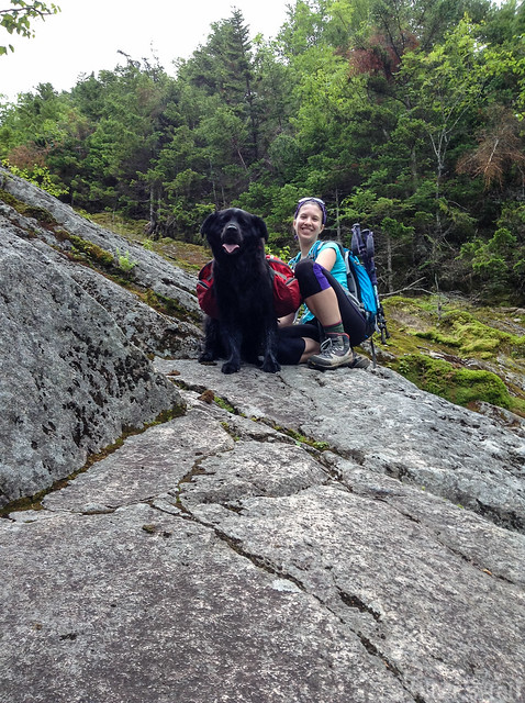
| Loop junction! |
Our Trip started on the Livermore Trail. But you know what? It’s not really a trail. It is a ROAD! A nice, smooth, dirt road that my car could drive on. But did we drive? nope. We walked 3.6 miles on a ROAD. I mean, it’s not hard but it is kind of boring. The loop starts at 2.6 miles but you have to go clockwise-north first so still another mile before the real trail!
 |
| Ready to climb |
At a sharp turn in the ROAD the Mt Tripyramid Trail starts! If you don’t like climbing don’t go this way. Or if it’s raining. Take the ROAD to the Scaur Ridge Trail. We wanted to do the traditional Loop so we went the hard way.
 |
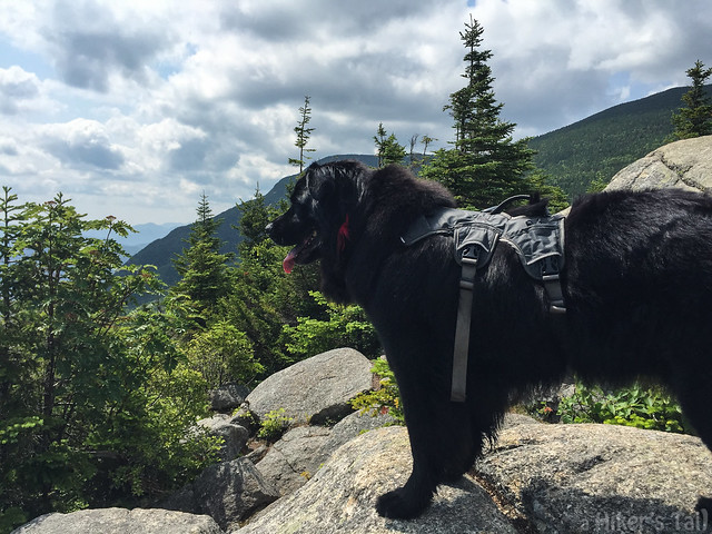
| Climb time |
The top half of the slide was easier because it wasn’t slippery or mossy. You can see a lot from up there. It was supposed to rain later that evening but there was already a cloud ceiling. Some mountains were touching the ceiling! We made friends with some girls who climbed up at the same time and traded photos. We kept passing each other on the trail. At North Tripyramid we took victory photos and ate first lunch. It was hard work rock climbing a mountain. We met a local who said it wouldn’t rain.
 |
| Hello mushroom |
After snacking (TurboPUP I love you), we continued on which meant going down and then back up to Middle Tripyramid. There was a friendly summit-mushroom welcoming us. We ate more food and met a Forester taking care of the forest. She said it wouldn’t rain.
We continued to South Tripyramid as the clouds were covering the mountains. we looked back at the pointy peaks and could just see them through fog. The South summit wasn’t much, probably because it doesn’t get the love. But guess what? It started raining! I need a raincoat. My Laura and Moriah have red raincoats. I should have one too. We took our time going down the South Slide because it was wet and slippery. It rained steadily for a while down the top half of the slide. It was steep but not as bad as the North side. It is more rocky-sandy instead of big slabs of rock. We kept taking our time and eventually got back to the trees and the not-steep part as the rain slowed down.
 |
| Misty Mountain |
When you’re done all the hard stuff, it is actually a long hike back. There are streams to drink and it is not steep but it takes a while. When you finally get back to the loop it is 2.6 miles on the Livermore ROAD back to the car. We ran a little bit on the ROAD because it is flat to speed it up. All together the hike is 11.1 miles but it actually doesn’t feel like that much because half of it is on a ROAD. But remember, half of it is STEEP STEEP STEEP. (Three steeps for three peaks!)
Bye!
~Frisco
North Tripyramid & Middle Tripyramid (& South Tripyramid)
Elevation: 4,180 & 4,140 ft (& 4,100 ft)
Distance: 11.1 miles
More photos!